Accessible Denbighshire
Latest News
Volunteer Programme April 2019 - September 2019
17.05.2019
Screening For Life Walk 01/07/2015
18.06.2015
More Information
Project funders

Facebook Page
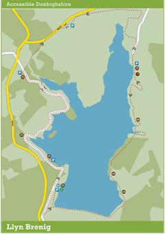
Llyn Brenig
Llyn Brenig was completed in 1976 and is used to regulate the flow of water to the River Dee. The full circular route is 15.2km or 9.5 miles, however shorter, linear routes may be taken from the visitor centre or any of the car parks.
! Please note that the Llyn Brenig Path will be closed between the 15-16th of November due to the Wales Rally GB. www.walesrallygb.com
Route Ideas:
A linear route from the visitor centre to the picnic area near Pont y Brenig is 4.2km / 2.6 miles each way and will take 45 minutes to 1 hour each way.
A linear route from the visitor centre, across the dam and up to the picnic area below Gors Maen Llwyd is 7km / 4.5 miles each way and will take 1 ½ - 2 hours each way.