Walking
Latest News
Screening For Life Walk 01/07/2015
18.06.2015
Get Walking in the New Year
30.12.2014
Facebook Page
Brenig Way - Geology
The Geodiversity of the Brenig Way, Denbighshire
Dr Jacqui Malpas, Geodiversity Officer, Clwydian Range Area of Outstanding Natural Beauty
The Brenig Way passes through a spectacular landscape formed by the geology and geomorphology, the geodiversity. Geodiversity links the rocks, minerals, fossils (geology) and soils with the landscape (geomorphology), heritage and culture of the area.
The story of the geodiversity of the Brenig Way starts about 490 million years ago. It is a story of millions of years of Earth movements as tectonic plates crashed into each other causing volcanoes, earthquakes, folding, and faulting of the rock. The story of mountains being built and destroyed, deep seas teeming with life, being formed and disappearing, the last Ice Age which sculpted the land to the flooding, landslides, weathering and erosion of today.

The Dee Valley dominates the start of the walk. This ancient river was running before the last Ice Age and is thought to be about 3 million years old. As Wales plunged into the last Ice Age about 73,000 years ago, ice from Snowdonia and the Arenig Mountains flowed down the valley to Bala and along the Dee Valley and on to Cheshire. This ice formed glaciers and ice sheets that covered the landscape carving and shaping the landscape. The ice was up to a kilometre thick.
The cliffs behind Corwen were formed when Wales lay deep in the southern hemisphere about 425 million years ago. This part of Wales was a deep sea called the Denbigh Trough, which over time filled with grit, sand and occasional tiny fossils of sea creatures called crinoids. This rock is called the Denbigh Grits and is also the rock of Caer Drewyn on the northern side of the valley. Iron Age people used this rock to build the impressive ramparts of the hillfort.

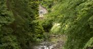
The River Dee meanders through the glacial deposits, left behind after the ice, and alluvium, deposits carried by the river from upstream and dumped as mud when the river floods, which it does each year. The effects of ice and a fast flowing river can be seen as the banks are eroding exposing large round boulders called glacial ‘erratics’; in the ‘wrong’ place.

When the glaciers melt, the sediment and rocks that were carried by the ice are dumped, mostly as glacial till, which drapes the landscape, and erratics that litter landscape. Study of the rock type of erratics and tracing them back to their origin, allows the flow of glaciers to be traced. The erratics in this part of Wales are from Snowdonia and the Arenig Mountains.
Climbing up the valley sides the rocks are Silurian mudstones. These muds were laid down in thin layers about 420 million years ago. They are now descriptively called ‘ribbon-banded’ mudstones. Over millions of years, huge Earth movements squeezed these mudstones forming shales and slate.
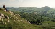
The path crosses onto the Denbigh Grits of Y Foel, the same rocks as those above Corwen. The Denbigh Grits are hard and resisted the ice, which is why they form the high ground here. The hills of Y Foel also follow the same trend as the Dee Valley, which confirms that the ice flowed from the south-west to the north east.
The valley around Glan-yr-afon is full of glacial deposits including small rounded hills called drumlins. To the west and south-west are glacial melt-water channels. When the ice started to melt about 17,000 yrs ago, the melt-water flow was initially under the ice. The running water would have carved out a tunnel and eroded a sub-glacial valley. The sediment carried by the meltwater was then deposited further down the valley & draped the landscape.

As you pass a small farmhouse at the top of Nant Rhyd-y-saeson, there is an enormous glacial erratic. This is the largest in North East Wales, it was even bigger as there are holes from rock drills where explosive was put to try to blow it up. Why was the farmhouse built do close to the erratic? It seems a strange thing to do.
The path above Nant Heulog and follows the contact between the Denbigh Grits & the underlying pale greenish-grey Bettws Mudstone. The Afon Alwen and Ceirw valley below is very steep-sided as it is a huge fault in the bedrock. Faults are weaknesses in the bedrock that water can exploit. This fault is one of a series of major faults, called the Bala Lineament, that run from the Welsh coast at Tywyn north easterly and under the Cheshire Plain. Huge volumes of melt-water would have exploited this weakness in the rock.
 The rocks along this part of the route are the older Ordovician Maerdy Mudstone Formation mudstones, which were deposited some 445 million years ago. The rocks have evidence of past life in the form of bioturbation; here it is the burrows of tiny worms that lived in muddy sediments without oxygen. Sometimes the rock looks mottled but occasionally tiny burrows can be found. Small outcrops of the Maerdy Formation are beside the path along Craig Arbuthy.
The valley sides of Melin-y-wig are draped in glacial till. Glacial till can be very unstable and there have been many landslips along the valleys, especially after heavy rain… we are in Wales.
Huge Earth movements during mountain-building events about 400 million years ago have pushed them up, folded and faulted the rocks of the steep-sided Afon Clwyd valley. The mountains were as high as the Himalayas today but have been destroyed by erosion and weathering. The processes were the same as those around the edges of the Pacific Ocean today. The remains of the volcanoes are in Snowdonia.
The rock changes entering Clocaenog Forest to the younger Silurian, Nantglyn Flags. As the name ‘flags’ implies, these rocks break up into large flat flags. The Nantglyn Flags have been extensively quarried and long been used for decoration, snooker tables, gravestones, building and dry-stone walls.
The Afon Clwedog valley is another steep-sided sub-glacial valley with the Nantglyn Flags forming the crags. The Afon Clywedog is a classic example of a miss-matched valley. The river seems much too small for the size of the valley. The valley was originally a glacial, U-shaped valley. The ice flowed over the landscape scraping the rock bare. When the ice melted, rivers flowed carving-out V-shaped valleys. Much of the landscape here has rounded hills and valleys, which are cut by sharp V-shaped and fluvial valleys and gorges.
When the path leaves the forest and up onto the highground, the rocks are still the Silurian Nantglyn Flags with stone used for the circles and cairns and other archaeological features. The stone used for these features does not seem to be the underlying Nantglyn Flags, but are probably glacial erratics, collected from the surrounding area.
Wales is still being changed by geological events with erosion, floods, landslides and very occasional mild earthquakes. The landscape is ever changing through human activity, the seasons and through time.