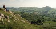
Special Landscapes
Latest News
Volunteer Programme April 2019 - September 2019
17.05.2019
Screening For Life Walk 01/07/2015
18.06.2015
Facebook Page
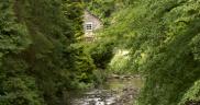
Historic Landscapes
What we see around us is a product of thousands of years of human influence. Farming, the building of settlements, the winning of valuable minerals and stone have all shaped to the familiar landscapes of today and contribute to the cultural richness and of the area and a distinctive local character.
Denbighshire contains sites of past human activity and occupation dating back to about 250,000 BC. Indeed the whole way the landscape looks today is a result of the way people have managed their environment for farming, subsistence, extraction, transportation and recreation over perhaps the last 5000 years.
There is evidence of people moving into the area during warm periods within the ice ages and then, from about 10,000BC, hunter gatherers moved back into the area more permanently. Initially these peoples moved about the landscape, following the seasons and the animals they hunted, leaving their tools in places like Prestatyn, Brenig and the outskirts of Denbigh.
By about 3000BC people began to farm and develop settlements and farmsteads. There is not a lot of evidence for this in the area, although a possible Neolithic (new stone age) house was found on the hillfort Moel y Gaer Rhosesmor in Flintshire. Monuments like Gop Cairn at Tremeirchion possibly date to the Neolithic.
By around 2000BC people in the area started to exploit metal as well as other materials like wood and stone. There is very little evidence of where these people lived although lots of evidence of where they were buried. Some of the easiest to see are on the archaeological trail at Llyn Brenig but there are also examples in the Clwydian Range and Llantysilio Mountain. The County contains many Bronze Age burial monuments, dating from about 2,000 to 800 BC. Evidence of settlements is limited but Bronze Age peoples may have used the sites of succeeding hillforts, as hinted at by the discovery of a Bronze Age hoard of copper axes at Moel Arthur, and similar activity at nearby Moel y Gaer, Rhosesmor
Once people had perfected the smelting of copper and bronze, technology progressed and iron was used. Iron needs a much hotter temperature to smelt. The information we have for the Iron Age, dating from about 800 BC to 43 AD, is the complete opposite to the Bronze Age. There are Iron Age hillforts, settlements crowning many of the hills in both the Clwydian Range and Llantysilio Mountains but nothing known about what happens to people when they died. Some of the forts are enormous perhaps most notably Penycloddiau to the more compact Moel Arthur and Moel y Gaer Llantysilio. They dominate the landscape now as in the past. Their function, both defensive and as sites of display, probably varied from controlling centres for territories stretching down from the hilltops to the valleys below; to tribal gathering places; summer grazing or sites of ritual.
Much of the landscape pattern visible today of villages and isolated farmsteads date from the medieval period. Churches of medieval origin lie in many of the villages in Denbighshire. Castell Dinas Bran is a stone built Welsh Castle built in the mid 13th century while Denbigh and Ruthin castles were established in the time of Edward 1st as an English control of Welsh land.
In more recent years the area has seen the development of some large parkland estates including Golden Grove, Llantysilio, Rug and Colomendy. Some developed following the accumulation of wealth built up from the expansion of local industries, particularly lead mining and slate quarrying as well as pottery and brick production, and extensive remains of this mining quarrying activity are still visible across the County.
Throughout the County water was harnessed to provide power; for lead mining particularly on the Alyn, whilst the River Wheeler was used to power corn mills, tin plate works, paper mills and sawmills. The Dee was extensively used with Llangollen a major centre of flannel production in the 19th century.. It is also from the Dee that water is abstracted to provide water for the Llangollen canal at Horseshoe Falls, now part of a World Heritage Site. It was at this time that transport began to change. Gradually a network of tracks both around and across the area were replaced or superseded as the use of motorised vehicles increased. Railways were developed and roads such as the A5 improved enormously.